


With 6-12″ of snow possible, November ends snowy in Colorado, carries storminess into December

After a rather dry November in Colorado’s high country, Loveland Ski Area recorded 25″ of snow for the month currently, December’s forecast looks more promising as more storms line up over the next week.
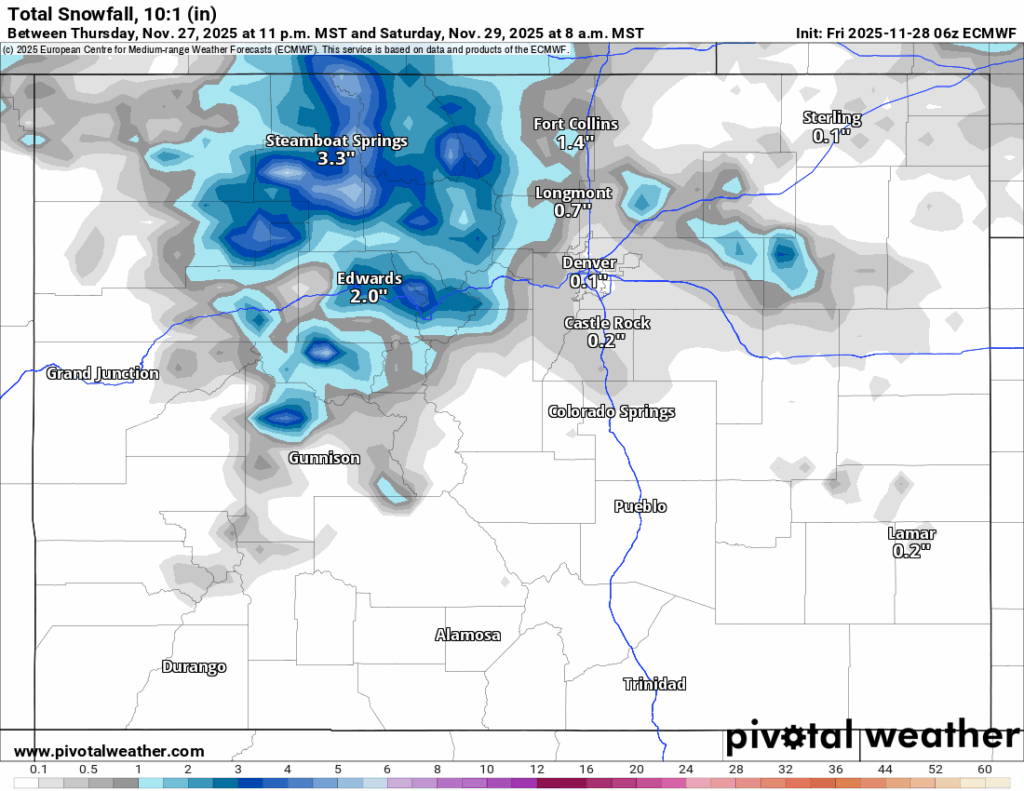
Snow returns Friday to close out the month on a snowy note, with the northern mountains benefiting the most.
As December begins, a larger system is forecast to bring between 6-12 inches for all three mountain zones, creating more base snow to allow ski areas to open more terrain and potentially the first powder day of the new month.
Recap:
Snow showers brought a touch of snow to the northern mountains on Wednesday.
Snowmaking was still happening at night, however, and with good efforts from the maintenance teams at Purgatory Mountain Resort north of Durango, the ski area announced Wednesday that it will open for skiing and riding today, Friday, Nov. 28.

Sixteen Colorado ski areas or resorts are now open as the last weekend of November starts.
Thanksgiving Thursday saw dry and cool conditions across the state’s ski areas, with high temperatures in the low 30s and upper 20s.
Forecast:
On Friday, warmer temperatures will precede a cold front dipping southeastward across Colorado Friday night, one which will bring snow to the northern mountains through Saturday afternoon.
Forecasted snowfall accumulations by Saturday’s first chairs in the northern mountains are between 2-4 inches, in the central mountains between 1-3 inches with the majority of snow falling in Pitkin and Gunnison counties, and in the southern mountains between a trace-1 inch with any snow falling only in the northern San Juans around Ouray and in the La Garita Mountains.
Snow returns Sunday (storm day) to all three mountain zones, and is forecast to last through Monday (“powder day”) afternoon.
This storm track has the northern mountains picking up an additional 3-7 inches, the central mountains an additional 3-7 inches and the southern mountains 5-9 inches.
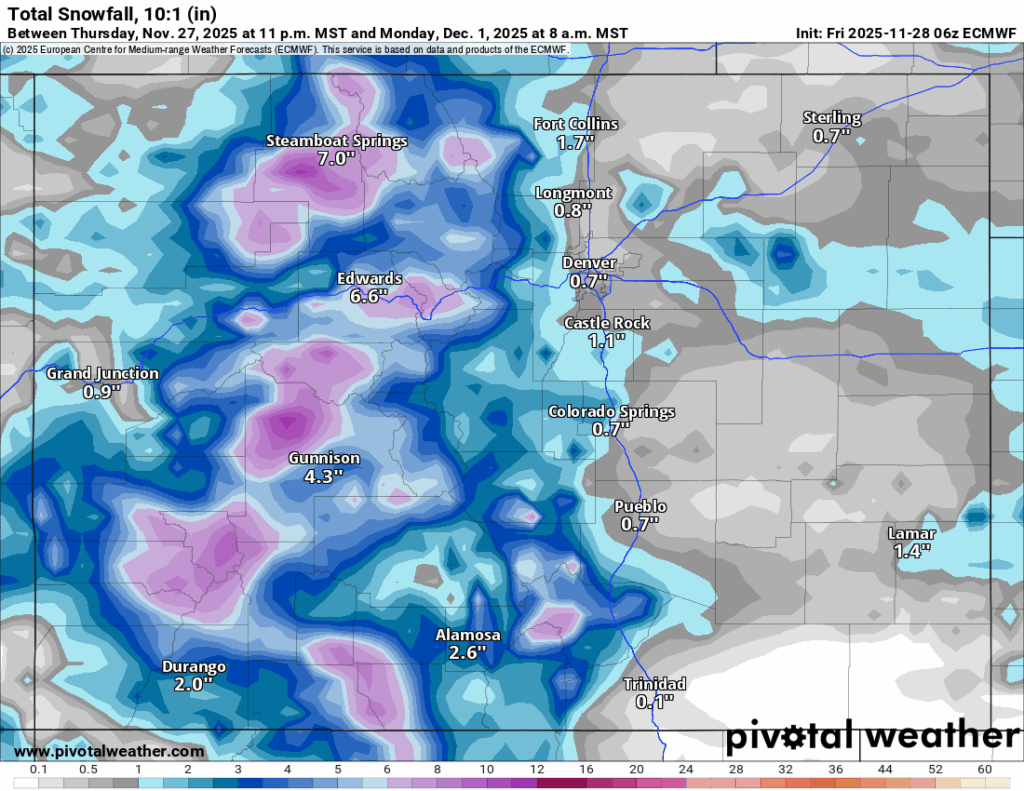
This area of low pressure is forecast to travel across the Four Corners region from northwest to southeast, hence snow for the northern mountains first, then spread into the central and southern mountains second.
Monday night could be one of the coldest nights so far across the high country, with forecast lows nearing 0 in some locales.
A return to snowy weather is possible on Tuesday night into Wednesday as a weak wave of storm energy passes through Colorado, favoring the northern mountains with between 1-3 inches possible, mostly in the Park and Medicine Bow ranges near the Wyoming state line. Some spill over snowfall into the central mountains is possible as well.
Long-term forecast:
Flurries are possible Thursday and Friday, again, mostly in the northern mountains as another wave of energy passes across northern Colorado.
A calmer first weekend of December (Saturday, Dec. 6 and Sunday, Dec. 7) is possible according to current weather models, but a better chance of snow is forecast to arrive Tuesday, Dec. 9.
More model runs will need rendering to hone in better details this far out, but December’s weather is appearing to be a lot more active than November’s.
Colorado ski resorts’ planned opening dates and 24-hour totals:
Arapahoe Basin – 0″
Aspen Highlands – Dec. 13
Aspen Mountain – 0″
Beaver Creek – Nov. 30
Breckenridge – 0″
Buttermilk – Dec. 13
Cooper – Dec. 10
Copper Mountain – 0″
Crested Butte – 0″
Echo Mountain – Dec. 12
Eldora Mountain – 0″
Granby Ranch – 0″
Hesperus – Closed for the season
Howelsen Hill – Nov. 29
Kendall Mountain – December
Keystone – 0″
Loveland – 0″
Monarch – Delayed, ASAP
Powderhorn – Delayed, ASAP
Purgatory – 0″
Silverton – Private mountain after Dec. 1, Guided and Heli season Dec. 27
Snowmass – 0″
Steamboat – 0″
Sunlight – Dec. 12
Telluride – 0″
Vail – 0″
Winter Park – 0″
Wolf Creek – 0″

National Renewable Energy Laboratory renamed to fit Trump’s energy policy
Bernadette Berdychowski
bernadette.berdychowski@denvergazette.com
Updated 58 minutes ago
The National Renewable Energy Laboratory based in Golden has a new name to match the shift in U.S. energy policy under President Donald Trump. The Department of Energy announced it renamed the National Renewable Energy Laboratory to the “National Laboratory...
Bernadette Berdychowski
Reporter

38-year-old cold case murder tied to infamous Denver area serial killer
Michael Braithwaite
michael.braithwaite@gazette.com
Updated 24 minutes ago
The Douglas County Sheriff’s Office announced a resolution to a 38-year-old cold case murder Tuesday. Using modern DNA and forensic analysis, the office determined that the killer of Rhonda Marie Fisher — found dead in 1987 — was Vincent Groves,...
Michael Braithwaite
Reporter

RTD changes downtown Denver transit schedules Saturday for Parade of Lights
Noah Festenstein
noah-festenstein@denvergazette.com
Updated 19 minutes ago
Denver’s Regional Transportation District is modifying transit schedules on Saturday as thousands expect to travel downtown for the Parade of Lights. 9NEWS’ 51st annual Parade of Lights celebration begins at 6 p.m. RTD officials warned travelers of bus and train...
Noah Festenstein
Reporter
Aurora to illuminate tree, ring in the holidays in annual festival
Kyla Pearce
kyla-pearce@denvergazette.com
Updated 16 minutes ago
Aurora will illuminate the city’s Christmas tree with thousands of light strands and ring in the holiday season Tuesday night with activities for all ages. The city’s annual holiday tree lighting event takes place at the Aurora Municipal Center, 15151...
Kyla Pearce
Reporter
Denver experiences driest November in four years, eighth driest in city history
Jonathan Ingraham
jonathan.ingraham@denvergazette.com
Updated 47 minutes ago
To say Denver residents experienced a dry November puts it mildly. It was not only the driest November since 2021, but the eighth-driest November since weather records began in 1872. The National Weather Service released its monthly weather summary for...
Jonathan Ingraham
Reporter
Colorado title board to review graduated income tax proposal for 2026 election
Marianne Goodland
marianne-goodland@denvergazette.com
Updated 3 hours ago
On Wednesday, the Secretary of State’s title board will review another attempt at a graduated income tax ballot measure for the 2026 general election. In October, the title board rejected two proposals submitted by the Bell Policy Center because they...
Marianne Goodland
Reporter

The Broadmoor unveils life-sized gingerbread display, a holiday tradition in Colorado Springs
Seth Boster
seth-boster@denvergazette.com
Updated 2 hours ago
A sweet tradition of epic proportions has returned to The Broadmoor. The famed, historic resort in Colorado Springs has unveiled its life-sized gingerbread display for the holiday season — a time-honored attraction with alternating themes. This year’s: a whimsical take...
Seth Boster
Reporter

Tracy Huggins, head of Denver Urban Renewal Authority for 25 years, to step down
Bernadette Berdychowski
bernadette.berdychowski@denvergazette.com
Updated 4 hours ago
The Denver Urban Renewal Authority will have a new executive director. The organization announced Tracey Huggins, who has run DURA for about 25 years, will step down and move into a senior advisor role. She will end her term on...
Bernadette Berdychowski
Reporter

Denver Broncos to guest star in Colorado Ballet’s ‘The Nutcracker’ again this year
Daniel Boniface
dan.boniface@denvergazette.com
Updated 2 hours ago
There’s a rare opportunity to see the Denver Broncos perform next Thursday night. And no, it’s not Thursday Night Football. The Colorado Ballet on Tuesday announced its Dec. 11 performance of “The Nutcracker” at the Ellie Caulkins Opera House will...
Daniel Boniface
Reporter
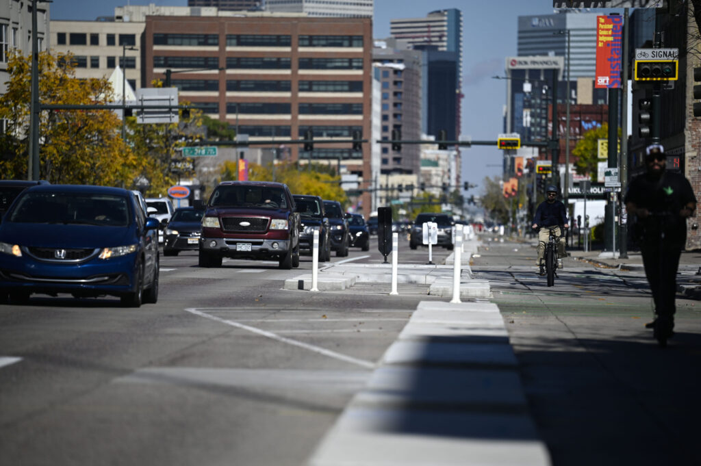
Broadway to close overnight Tuesday for sign bridge installation
Michael Braithwaite
michael.braithwaite@gazette.com
Updated 4 hours ago
Construction crews will close Broadway in both directions overnight Tuesday as they install an overhead sign bridge near Interstate 25. The closure, which will last from 10 p.m. Tuesday through 4 a.m. Wednesday, will impact Broadway between Ohio and Tennessee...
Michael Braithwaite
Reporter
PREV
PREVIOUS
Denver weather: Cold front Friday night forecast to end city's snowless streak at 224 days
It is probable Denver sees its first snowfall on Saturday as a cold front dips southeastward across Colorado Friday afternoon and evening, potentially ending the snowless streak at 224 days (fourth longest in recorded city-weather history). But for today, Denver residents can expect mostly cloudy skies, with a high near 62, according to the National […]

Colorado man with a big heart gets a new heart - literally
To John Babiak, every person in the world is a friend. How appropriate, then, that two people he had never met saved his life. This August, the coach and former science teacher found himself on his 66th birthday in an intensive care unit with a grim diagnosis – his heart was failing. “The whole team […]