


Up to 49″ of snow could hit Colorado peak this week amid ‘winter storm warning’
Memorial Day Weekend may be a week away and all of Colorado’s ski areas are (as of this past weekend) closed around the state, but don’t be fooled by the date – more snow is inbound. While the past winter season brought record-setting snowpack lows, spring has turned the snow season into a sort of winter that just won’t quit. Per the National Weather Service, totals in the range of 18 to 24 inches of snow could hit this week if a ‘high-end’ snowfall scenario comes to fruition and some sources indicate totals could be even higher. Either way, a good amount of fresh powder is expected, and there will likely be impacts.
As has been the case with recent snowstorms that have blown through, this storm is set to favor Northern Colorado, specially the stretch of the Continental Divide found north of and around I-70, including Rocky Mountain National Park. The majority of the snow is expected on Monday and Tuesday, though moisture could continue into Wednesday and Thursday, as well.
Let’s start with the most likely scenario – the ‘expected’ snowfall scenario, which comes with an 80 percent chance.
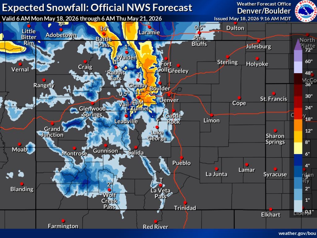
In this scenario, The heaviest totals are really only expected along the aforementioned stretch of the Continental Divide and the area around it, though similar totals could also land in the area of the Park Range, north of Steamboat Springs. Per the National Weather Service, this scenario brings peak totals of about 12 to 18 inches through Thursday morning to high peaks in this region, with a chance of Mount Blue Sky getting totals in the range of 18 to 24 inches – though Mountain-Forecast.com calls for about 26 on this iconic peak (and even more on another, more on that below). It’s also worth noting that while warmer temperatures may prevent significant accumulation in lower elevation areas even if a lot of snow falls, snow may be more likely to stack up on impacted peaks.
Other mountainous regions around the state would be looking at about one to six inches of snow, with the Front Range mostly missed with the exception of flurries just south of Castle Rock. About 11 inches of snow is expected along I-70 in the area of the Eisenhower Tunnel, though deeper totals could accumulate along this highway just east of this tunnel complex. That said, warmer temperatures will likely have much of this snow melting off quickly.
See this scenario depicted on the map below and keep scrolling for the ‘high-end’ snowfall forecast:
While the more likely ‘expected’ snowfall forecast brings enough snow to have an impact on mountain travel, perhaps more interesting is the ‘high-end’ scenario, which comes with a 10 percent chance.
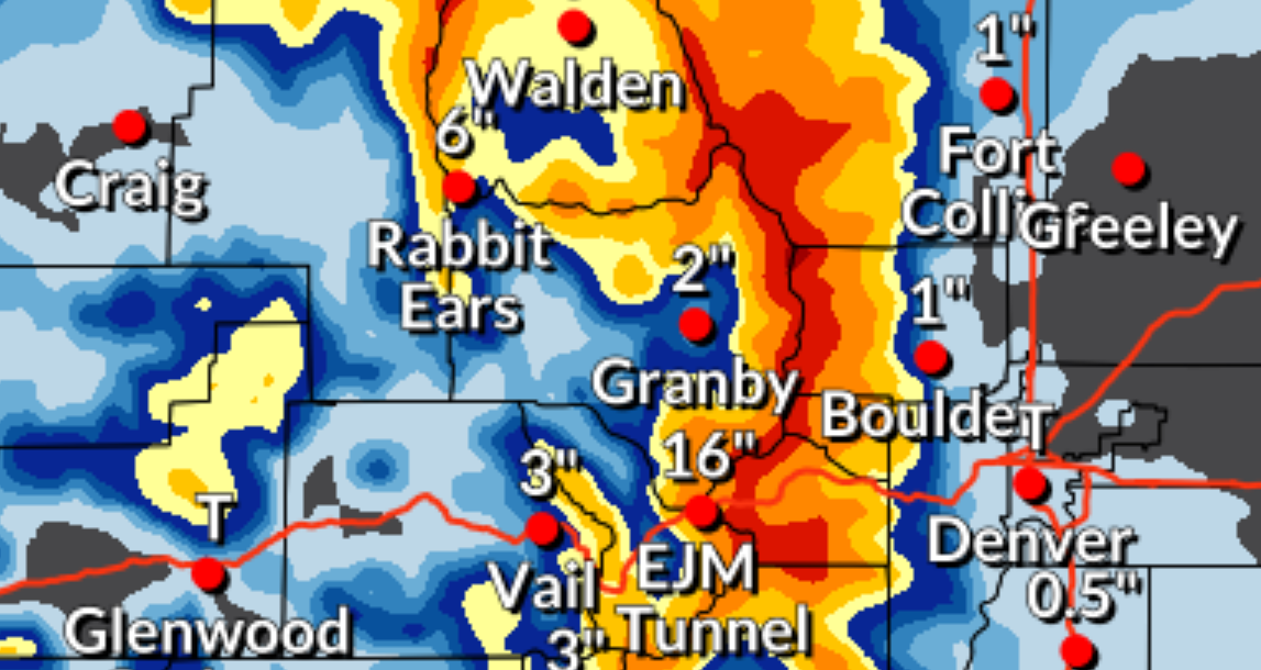
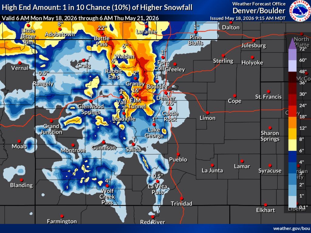
In this scenario, snowfall totals in the range of 18 to 24 inches are expected along the northern stretch of the Continental Divide, with the possibility of about 24 to 30 inches on 14,259-foot Long Peak – again, Mountain-Forecast.com predicts these totals will be a bit higher than what the National Weather Service is calling for, at about 43 inches through Thursday morning with about six additional inches on Thursday night (around 49 inches total this week – note: keep in mind that this website adjust totals regularly, so expectations may be subject to increasing or decreasing as the storm progresses).
Meanwhile, the ‘high-end’ snowfall scenario also calls for more notable totals on Central Colorado peaks – about six to 12 inches. The Front Range is still mostly missed, though areas along I-25 from Monument northward could get flurries. In this high-end scenario, 16 inches of snow falls at the Eisenhower Tunnel with totals of 18 to 24 inches expected along the stretch of I-70 just east of this tunnel complex.
See this ‘high-end’ scenario depicted below:
Whether the ‘expected’ scenario or the ‘high-end’ scenario hits, it’s looking like significant snow is to be expected in northern Colorado. Considering that most of it should fall between Monday and Tuesday, rapid rates of snowfall could occur, too. A ‘winter storm warning’ has been activated for part of northern Colorado, with a ‘winter weather advisory’ activated in the area around that. The ‘winter storm warning’ warns of ‘very difficult’ travel and dangerous evening and morning commutes (additional details on those advisories can be found on the National Weather Service website). A big factor in travel risk will be how much snow ultimately sticks – as was noted, roadway snow may melt quickly.
A key potential impact to watch for could be a delayed opening of Trail Ridge Road despite the dry year. Crews typically aim to get this popular route in Rocky Mountain National Park open the Friday of Memorial Day Weekend, but with significant snow last week and significant snow this week, quite a bit of clearing work is likely needed for that to be a possibility. Remember, Mountain-Forecast.com is calling for up to 49 inches of snow this week on the nearby Longs Peak. This high-elevation road hits 12,183 feet above sea level and this area will close this round of wintery weather with several feet of snow in May.
As of May 18, Colorado’s statewide snowpack hovers just above record-lows, still on pace to be gone a couple weeks ahead of the norm. The snowpack is at 12 percent of the median, per the USDA.
Find additional forecasting information on the National Weather Service website.
STAY INFORMED: Get free Colorado news with our daily newsletter (Click here)
Get OutThere
Signup today for free and be the first to get notified on new updates.
PREV
PREVIOUS

90 bison removed from Moffat County ranch in animal neglect case
The Moffat County Sheriff’s Office (MCSO) seized approximately 90 head of bison and a mule from a ranch in Moffat County on Saturday. According to a press release from the MCSO, the sheriff’s office worked with the Colorado Bureau of Animal Protection and the Colorado State Veterinary Office to execute a seizure operation from the […]

Man who died on Flatirons ID'd as climbing community speculates on what went wrong
On May 14, a man was found dead in a gully on Boulder’s Second Flatiron. That man has since been identified as 33-year-old Ryan Kelly An Apple Crash Detection alert from an Apple device originating in the area of Boulder’s Chautauqua Park alerted authorities about a potential incident around 11:30 a.m. on May 14. Aside […]