


Conditions rivaling Marshall fire forecast for Friday
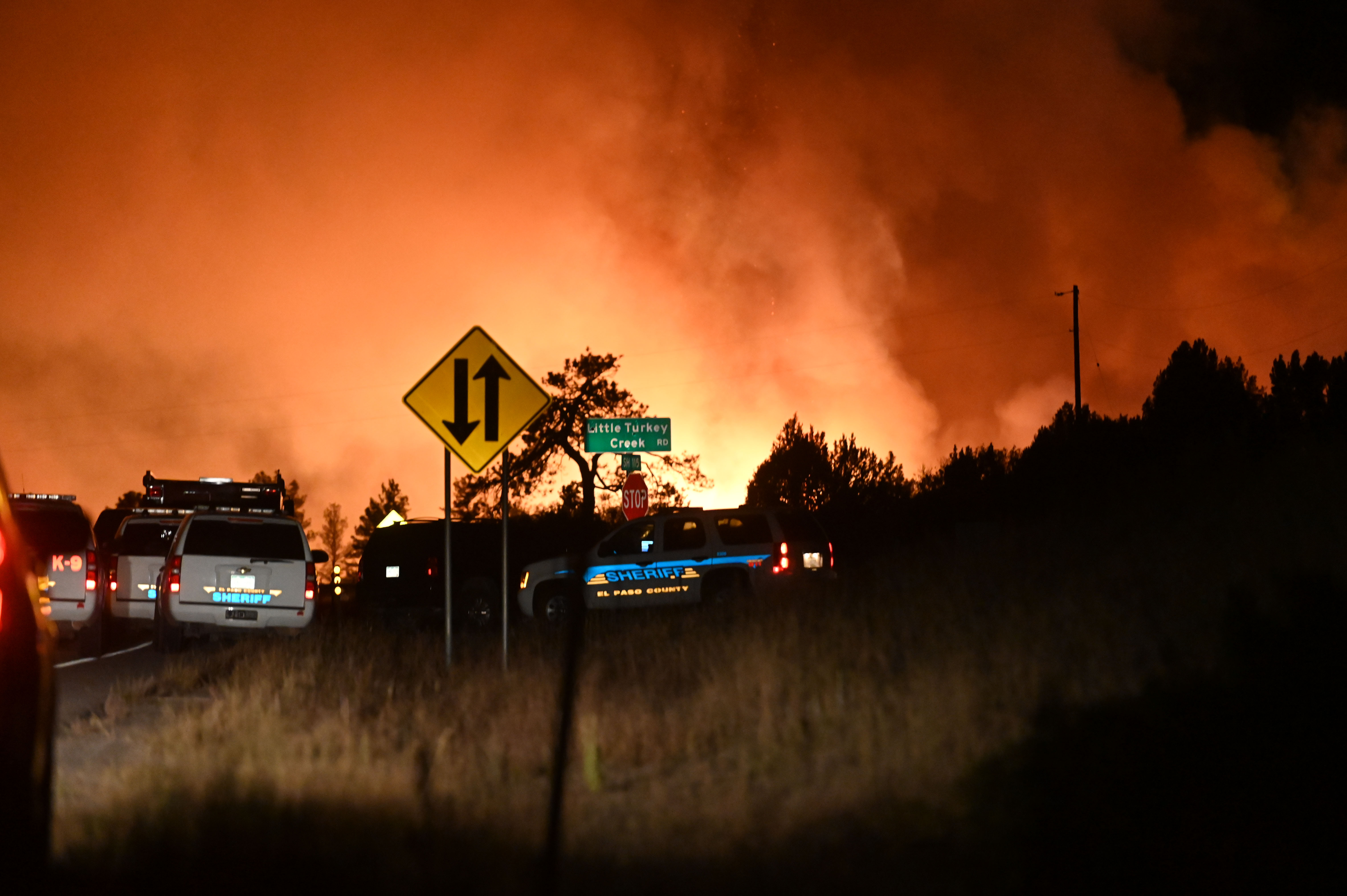
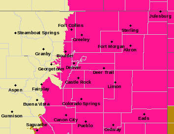
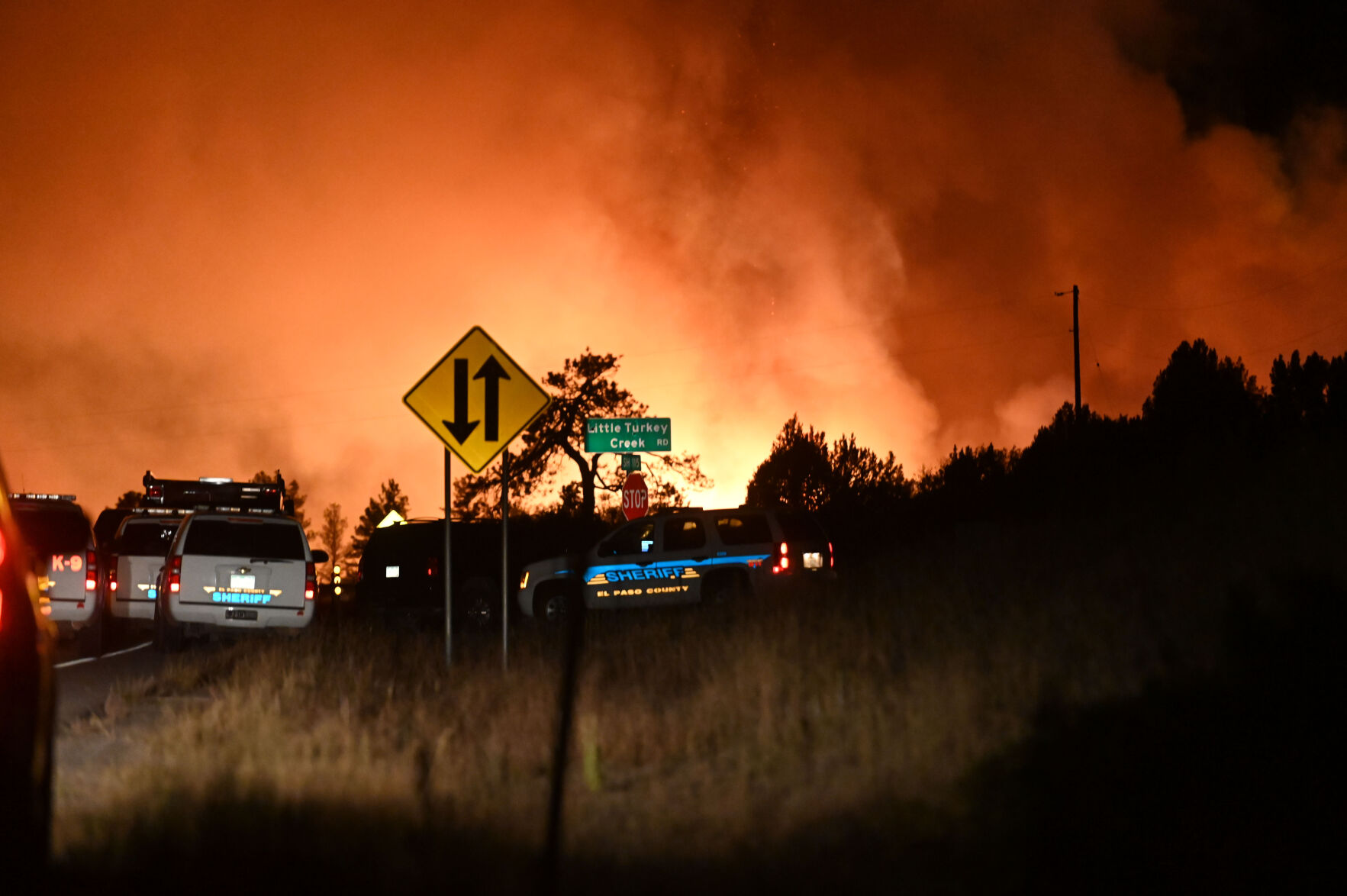
The National Weather Service has issued a Red Flag Warning for over half of the state Friday, citing conditions that are even more severe than they were for the Marshall fire.
“There’s a much larger area under the gun than there was for the Marshall fire,” said Greg Hanson, warning coordination meteorologist for the National Weather Service in Boulder. “The Marshall fire was isolated to that one part of Boulder County. The winds Friday won’t be as strong, but we are experiencing much drier conditions.”
Hanson said unusually high temperatures for April will add to the dire conditions.
Friday’s alert predicts that the region south of Interstate 76 and east of Interstate 25 will have wind gusts of up to 60 miles per hour in the afternoon at the hottest time of the day. Sustained winds will blow from 30-40 mph.
According to the National Weather Service, there will be 30 to 45 mph gusts extending north and west as well. Adding to the fire danger are abnormally low humidity levels for early spring, which are predicted to be in the single digits.
Along the Front Range and Northeastern Plains, there have only been three days this month that have not had a Red Flag Warning: April 1, 2 and 4, according to the National Weather Service. The numbers for the Pueblo area are the same.
“We’ve had 18 days in April where we’ve had active Red Flag Warnings. We’re getting hard hit by winds and low humidity from Pueblo east to Kansas and south to New Mexico,” said meteorologist Mike Garberoglio, who forecasts out of the Pueblo office.
Along Colorado’s Western Slope, late snows have quenched the fire danger. April has seen three days of Red Flag Warnings, according to the National Weather Service office in Grand Junction.
In response to the high number of Red Flag days, agencies such as Boulder Fire-Rescue will increase staffing and local patrols on these days, Boulder officials announced Thursday.
“Increasing staffing also helps ensure that the department will have firefighters ready to respond (to) emergency calls in the city that may occur on any given day,” according to a statement from the city.
Hanson said the La Niña weather pattern has caused an extremely dry April for the state with less than 100th of an inch of moisture. The normal precipitation for April is about an inch.
“Typically March and April are our big precipitation months. We usually get big snowstorms that kick off the summer. It hasn’t materialized this year,” said Hanson.
To qualify for a Red Flag Warning designation, humidity must be below 15% and wind gusts must be over 25 miles per hour. There was no official Red Flag Warning before the Marshall fire because the humidity that day was in the 20% range.
A little over two hours east of Denver in Yuma County, the volunteer fire department had an emergency meeting Wednesday night to prepare for the possibility of wildfires during what is expected to be a freakishly dry, windy Friday afternoon.
“It’s going to be a bugger for sure,” Joes Assistant Fire Chief Michelle Smith told The Denver Gazette.
Yuma fire officials discussed how to manage controlled burns and the necessity of blurring district boundary lines for dispatch and firefighters during these parched months.
Smith said it’s important for Yuma’s 13 fire departments dotting the rural, arid community to communicate to each other during Friday’s Red Flag event so that every single corner is under watch.
“A fire may start in someone else’s district, but I may have a straighter shot on dirt roads from my end. We want to get the appropriate amount of crews and water trucks to the fire. I don’t care if it’s my district or yours. We want to get the fire out. That’s the plan,” said Smith, a volunteer firefighter who moved back home to manage the family farm.
In October, Joes’ volunteer firefighter Larry Wyant died when the bearing on a combine broke off, causing it roll out of control into a cornfield where a spark lit a huge fire. Smith said the flames were so hot and burning so fast that Wyant was killed in under a minute.
Lucas Boyer, a meteorologist with the National Weather Service office in Grand Junction, said the Western Slope is in pretty good shape for now.
“We are waiting for critical fuels to develop. That’s the big part of the equation for us. We have the heat and wind, but burnable materials are not at critical levels yet,” said Boyer.
Grand Junction’s highs Thursday were at 80 degrees, which Boyer said are around 15 degrees above normal for this time of year.
Hanson said Red Flag Warnings used to be directed toward first responders so that they could prepare for the worst, but that in the last 15 years, the general population has become aware of them and he hopes Colorado residents will respond by refraining from burning trash and watching for any small fires in their area. He said if your lips are feeling especially chapped, it’s a dry day.
“What you’re feeling on your body from the dryness is also happening to the grasses and small twigs,” he said.
Denver Gazette reporter David Mullen contributed to this report.


Conditions rivaling Marshall fire forecast for Friday
The National Weather Service has issued a Red Flag Warning for over half of the state Friday, citing conditions that are even more severe than they were for the Marshall fire.
“There’s a much larger area under the gun than there was for the Marshall fire,” said Greg Hanson, warning coordination meteorologist for the National Weather Service in Boulder. “The Marshall fire was isolated to that one part of Boulder County. The winds Friday won’t be as strong, but we are experiencing much drier conditions.”
Hanson said unusually high temperatures for April will add to the dire conditions.
Friday’s alert predicts that the region south of Interstate 76 and east of Interstate 25 will have wind gusts of up to 60 miles per hour in the afternoon at the hottest time of the day. Sustained winds will blow from 30-40 mph.
According to the National Weather Service, there will be 30 to 45 mph gusts extending north and west as well. Adding to the fire danger are abnormally low humidity levels for early spring, which are predicted to be in the single digits.
Along the Front Range and Northeastern Plains, there have only been three days this month that have not had a Red Flag Warning: April 1, 2 and 4, according to the National Weather Service. The numbers for the Pueblo area are the same.
“We’ve had 18 days in April where we’ve had active Red Flag Warnings. We’re getting hard hit by winds and low humidity from Pueblo east to Kansas and south to New Mexico,” said meteorologist Mike Garberoglio, who forecasts out of the Pueblo office.
Along Colorado’s Western Slope, late snows have quenched the fire danger. April has seen three days of Red Flag Warnings, according to the National Weather Service office in Grand Junction.
In response to the high number of Red Flag days, agencies such as Boulder Fire-Rescue will increase staffing and local patrols on these days, Boulder officials announced Thursday.
“Increasing staffing also helps ensure that the department will have firefighters ready to respond (to) emergency calls in the city that may occur on any given day,” according to a statement from the city.
Hanson said the La Niña weather pattern has caused an extremely dry April for the state with less than 100th of an inch of moisture. The normal precipitation for April is about an inch.
“Typically March and April are our big precipitation months. We usually get big snowstorms that kick off the summer. It hasn’t materialized this year,” said Hanson.
To qualify for a Red Flag Warning designation, humidity must be below 15% and wind gusts must be over 25 miles per hour. There was no official Red Flag Warning before the Marshall fire because the humidity that day was in the 20% range.
A little over two hours east of Denver in Yuma County, the volunteer fire department had an emergency meeting Wednesday night to prepare for the possibility of wildfires during what is expected to be a freakishly dry, windy Friday afternoon.
“It’s going to be a bugger for sure,” Joes Assistant Fire Chief Michelle Smith told The Denver Gazette.
Yuma fire officials discussed how to manage controlled burns and the necessity of blurring district boundary lines for dispatch and firefighters during these parched months.
Smith said it’s important for Yuma’s 13 fire departments dotting the rural, arid community to communicate to each other during Friday’s Red Flag event so that every single corner is under watch.
“A fire may start in someone else’s district, but I may have a straighter shot on dirt roads from my end. We want to get the appropriate amount of crews and water trucks to the fire. I don’t care if it’s my district or yours. We want to get the fire out. That’s the plan,” said Smith, a volunteer firefighter who moved back home to manage the family farm.
In October, Joes’ volunteer firefighter Larry Wyant died when the bearing on a combine broke off, causing it roll out of control into a cornfield where a spark lit a huge fire. Smith said the flames were so hot and burning so fast that Wyant was killed in under a minute.
Lucas Boyer, a meteorologist with the National Weather Service office in Grand Junction, said the Western Slope is in pretty good shape for now.
“We are waiting for critical fuels to develop. That’s the big part of the equation for us. We have the heat and wind, but burnable materials are not at critical levels yet,” said Boyer.
Grand Junction’s highs Thursday were at 80 degrees, which Boyer said are around 15 degrees above normal for this time of year.
Hanson said Red Flag Warnings used to be directed toward first responders so that they could prepare for the worst, but that in the last 15 years, the general population has become aware of them and he hopes Colorado residents will respond by refraining from burning trash and watching for any small fires in their area. He said if your lips are feeling especially chapped, it’s a dry day.
“What you’re feeling on your body from the dryness is also happening to the grasses and small twigs,” he said.
Denver Gazette reporter David Mullen contributed to this report.
Conditions rivaling Marshall fire forecast for Friday
Friday is expected to be the windiest and warmest day of the week as high fire danger continues.