


‘Bomb cyclone’ won’t hit Colorado, yet Thanksgiving week looks to be the ‘BOMB’ | Whiteout snow report
Plus Monarch Mountain opens Friday, Steamboat Saturday

It’s a shame the atmospheric river inundating the Pacific Northwest will not be bringing moisture to Colorado this week — go ski or ride Mt. Shasta, California.
Tens of trillions of gallons of water are expected to fall from this storm. The National Weather Service offices on the west coast forecast for places in Washington, Oregon and northern California to have snow accumulations approaching between 3-7 feet.
Even though Colorado won’t benefit from this storm, be thankful because next week’s potential snows keep becoming more promising each day.
Plus, Monarch Mountain welcomes skiers and riders to its slopes Friday for opening day as the central Colorado mountain celebrates its 85th year in operation.
“Each year, our goal is to start the lifts as early as possible, and thanks to Mother Nature and the relentless efforts of our incredible mountain operations team, a November opening is happening!” said Christopher Haggerty, General Manager at Monarch Mountain.
The ski area plans to run the Pioneer, Garfield, Tumbelina and Caterpillar lifts and ski area crews will evaluate conditions and will release the grooming report at 6 a.m., opening day.
Recap:
Wind and more wind blew across Colorado’s high country Tuesday, but skiers and riders were welcomed to between 2-7 inches of new snow for first chair in the northern mountains. Copper Mountain and Breckenridge received the highest amounts.
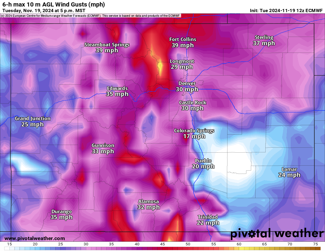
Wind gusts along the northern Front Range mountains pushed upward of 60 mph in Rocky Mountain National Park and the Indian Peaks Wilderness. Lake Isabelle recorded a gust of 56 mph around noon and closer to ski area Winter Park atop Berthoud Pass, a gust reached 36 mph around 11 a.m.
Additional snow accumulations in the northern mountains were between 1-4 inches, in the central mountains between 1-3 inches and in the southern mountains a trace-1 inch.
Forecast:
On Wednesday, temperatures start out very cold for today’s date, with single digits and even a few spots below 0. The sun will come out and warm up the air, with highs pushing back into the low to middle 30s. Winds will whip around again, however, with gusts along the Front Range mountains the highest as speeds could reach between 60-70 mph.
Thursday through Saturday will be much of the same, but warmer still, as highs push into the 40s ahead of the Thanksgiving week.
On Sunday, the shift starts, and snow returns to Colorado’s high country starting late morning into early afternoon.
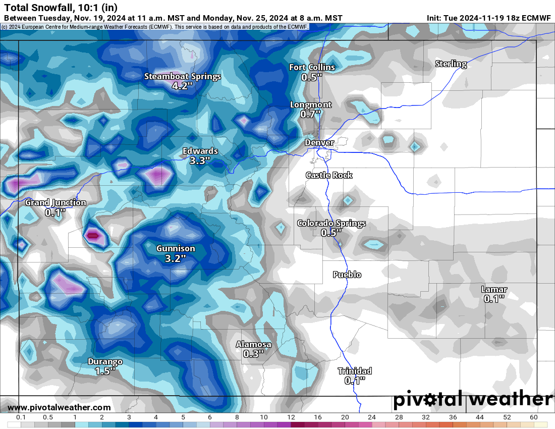
The ECMWF forecast model has an area of low pressure forming over western Montana on Saturday, then is forecast to slide southeastward into Wyoming, and eventually into eastern Colorado.

This storm front should bring snow to the north and central mountains mainly, with accumulations between 1-3 inches in the northern mountains and a trace-2 inches in the central mountains for first chairs on Sunday.
However, by Monday’s first chairs, forecasted snow accumulations will have increased, with between another 2-6 inches in the northern mountains, 3-8 inches in the central mountains and 2-6 inches in the southern mountains.
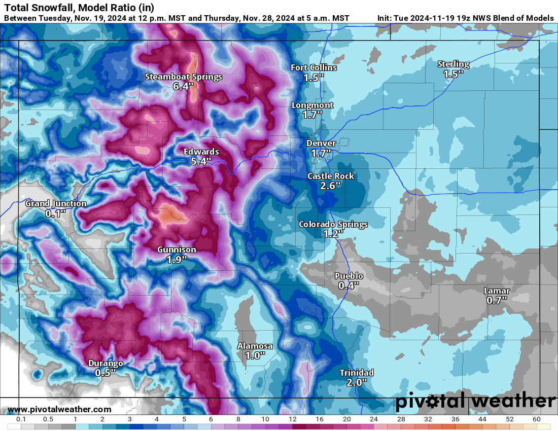
The American GFS forecast model has more snow accumulating in Pitkin and Gunnison counties for Monday morning, with accumulations between 8-14 inches and up to 21 inches.
However, the NWS Blend model forecasts accumulations of between 6-10 inches around Aspen/Snowmass and Crested Butte, but also more snow in the northern mountains around Steamboat, with accumulations between 6-12 inches and the Flattops 6-10 inches.
Snow continues into Monday night and Tuesday, with additional accumulations for all mountain zones from between 3-6 inches in the northern mountains, 4-7 inches in the central mountains and between 4-6 inches in the southern mountains. Tuesday’s first chairs will either be the deepest and/or softest after multiple days of week-day snows, even with Thanksgiving break starting.
One thing to remember is even though snow is forecast and will fill in the slopes more, very little terrain will be open at some of the larger resorts because it’s still somewhat early and terrain at resorts with better coverage may still have ‘snow sharks and snakes’ (rocks and branches) waiting to snag the bottom of your skis or board.
But new snow equals new terrain openings. Expect some ropes to drop throughout the week.
Snow continues Tuesday night through Wednesday, on a westerly flow as another low pressure system slides across the central Rockies with ample moisture associated with it from the Pacific Ocean.
The NWS Blend Total snowfall 10:1 (in) forecast for Wednesday’s first chair offers an additional 6-10 inches in the northern mountains (mostly around Steamboat), 6-10 inches in the central mountains (Pitkin and Gunnison counties highest chance), and 4-8 inches in the southern mountains.
A Thanksgiving ‘Powder’ Day is in order more than likely, plus Beaver Creek and Crested Butte open Wednesday, Nov. 27 and Snowmass, Aspen Mountain, Telluride and Granby Ranch open Thursday, Nov. 28.
Long range:
Snow showers will taper off heading into Friday, Nov. 29 and Saturday, Nov. 30, but some snow could potentially fall the last couple of November days and first few December days. More details on this notion will emerge as the dates near.
Today’s 24-hour snow totals from Colorado resorts:
Arapahoe Basin – 2″
Aspen Highlands – Closed for the season
Aspen Mountain – Closed for the season
Beaver Creek – Closed for the season
Breckenridge – 3″
Buttermilk – Closed for the season
Cooper – Closed for the season
Copper Mountain – 2″
Crested Butte – Closed for the season
Echo Mountain – Closed for the season
Eldora Mountain – 1″
Granby Ranch – Closed for the season
Hesperus – Closed for the season
Howelsen Hill – Closed for the season
Kendall Mountain – Closed for the season
Keystone – 2″
Loveland – 2″
Monarch – Opens Nov. 22
Powderhorn – Closed for the season
Purgatory – 0″
Silverton – Closed for the season
Snowmass – Closed for the season
Steamboat – Opens Nov. 23
Sunlight – Closed for the season
Telluride – Closed for the season
Vail – 4″
Winter Park – 1″
Wolf Creek – 4″