


Colorado’s snowpack is fourth lowest in nearly 40 years, struggled to reach average
Only 6 ski areas received over 300 inches of snow on the season | Whiteout

From below-average snowfall at Colorado’s ski areas to below average Snow Water Equivalent (SWE) levels and snowpack statewide, several not-so-grandioso monikers were recorded across Colorado during winter 2024-25.
First off, Colorado’s median SWE levels heading into May are the fourth lowest since winter 1986-87, after peaking between April 7-9. The state’s snowpack reached it’s highest overall percentage-of-median average in mid-January at around 95%, then recessed into below-average ranges for the remainder of the winter.
Furthermore, multiple dry and warm spells occurred during winter 2024-25, especially in southern Colorado’s San Juan Mountains. From Nov. 28 to Dec. 24, Jan. 9 to 29 and Feb. 17 to March 3, Purgatory Mountain Resort received no measurable snow, marking three 15-day or longer periods with no snow recorded.
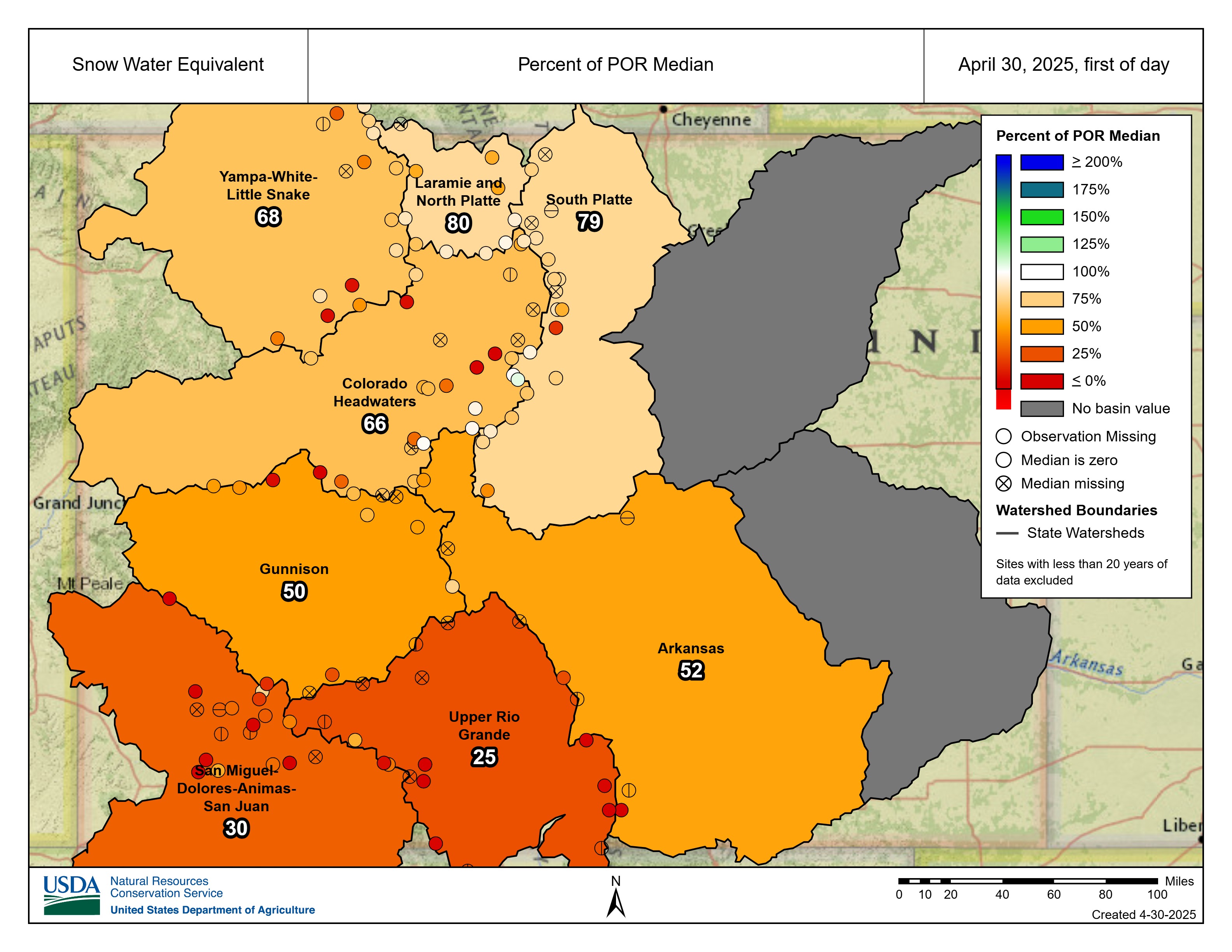
SWE history across Colorado’s eight mountain river basins
The highest recorded SWE level was from winter 1992-93 when SWE peaked at 25.9 inches on April 20 and 23.7 inches on April 30. The latest highest SWE level was in winter 1994-95 on May 14, when the SWE level was at 24.2 inches.
The current year’s snow water equivalent level on April 30 was 7.8 inches, which was only 0.1 inches above 2018’s snow water equivalent of 7.7 inches, and is 59% of average median snowpack.

2018 was the most recent year where below average snowpack and snow water equivalent levels occurred in Colorado.
Subsequently, only winter 2001-02 (4.1 inches) and winter 2011-12 (3.9 inches) had lower snow water equivalent levels on April 30, dating back to winter 1986-87.
Drying out in the southwest
Colorado’s river basins in winter 2001-02 experienced below average snowfall throughout the season and the two main southwest river basin systems — the San Juan, Dolores, San Miguel and Animas, and the Upper Rio Grande — only had 10% and 12% of median average respectively as of April 30 in their drainage systems.

Subsequently, warm and dry spells throughout April and May melted away almost all the moisture in the soils leading to the start of the Missionary Ridge fire northeast of Durango on June 9, 2002.
Heading into May, this year’s southern Colorado’s river basins are not near the low SWE levels seen in 2002, but their levels are still problematic as the increase in fire danger and drought loom.
The two southern Colorado river basins are at 30% and 25% of median average respectively.
What research has to say about the snowpack and SWE
Colorado State University Climatologist and Director of the Colorado Climate Center Russ Schumacher broke down some facts about the state of the snowpack in Colorado, in particular southwestern Colorado, in an April 14 article with CSU.
According to Schumacher, at the Upper San Juan SNOTEL station near Wolf Creek Pass, measurements show the second-lowest peak SWE since the station was established in 1979, worse than 2018 — which was a terrible drought and wildfire year in southwestern Colorado — though still ahead of the historic 2002 drought year.
“Through the San Juan and Sangre de Cristo mountains, many stations are below the 10th percentile,” Schumacher said. “Several had their lowest or second-lowest peak snowpack since they were installed; most were established in the late 1970s or early 80s.”
Schumacher said the overall downward trend doesn’t mean Colorado’s mountains can’t still get years with big snowpack — some of the same locations that are near record lows this year were near record ‘highs’ in 2019 and 2023, “but the bad years are outnumbering the good ones over time.”

According to Schumacher, the poor mountain snowpack and early melt-out in this year aligns with the trends in Colorado’s southern mountains over the last 40-plus years.
“In Colorado’s northern mountains, trends over the last 45 years are fairly modest overall, with some mixed signals,” he said. “But in the southern mountains, the data make a very clear statement: snowpack is declining, and the peak is happening earlier.”
Schumacher pointed to a combination of factors responsible for these trends.
“The 1980s were unusually wet, so the recent declines look even worse; rising temperatures globally and especially in the interior west, and increases in dust-on-snow that reduces the ability of snow to reflect sunlight,” Schumacher said. “Heat waves in April, like the one we’ve experienced in recent days, don’t help the situation either.”

According to Schumacher, many of the remote sensing stations in the San Juan and Sangre de Cristo mountains show the peak SWE has declined by 3-5% per decade, and the peak has shifted 2-4 weeks earlier.
“When this year’s poor snowpack gets incorporated, these trends might look even steeper,” he said.
How Colorado’s ski areas faired in 2024-25
Only two ski areas — Vail and Steamboat — that closed before the last day of April eclipsed 300 inches or greater of season-totaling snowfall. Currently only six ski areas have recorded over 300 inches of snow or greater as well.
Usually at least 10 Colorado ski areas or resorts receive, on average, 300 inches of snow or greater each season. Only seven eclipsed 300 inches or greater during winter 2024-25.

The two standouts to not make the 300-inches-plus club this season were Silverton and Wolf Creek, whom regularly rank in the top five every year for the ‘most snow in Colorado’ title.
Season snowfall totals for winter 2024-25
- Winter Park – 360″, and counting
- Copper Mountain – 340″
- Vail – 324″
- Breckenridge – 326″
- Loveland – 327″
- Steamboat – 304″
- Aspen Highlands – 292″
- Silverton – 285″
- Snowmass – 277″
- Arapahoe Basin – 262″, and counting
- Keystone – 256″
- Beaver Creek – 250″
- Aspen Mountain – 240″
- Crested Butte – 230″
- Wolf Creek – 228″
- Telluride – 223″
- Monarch – 222″
- Ski Cooper – 221″
- Eldora Mountain – 219″
- Powderhorn – 196″
- Purgatory – 173″
- Buttermilk – 163″
- Sunlight – 153″
- Kendall Mountain – 147″
- Granby Ranch – 110″
- Howelsen Hill – 85″
- Echo Mountain – 73″
- Hesperus – Never opened this season, mechanical issue
According to OnTheSnow.com, the statewide average between all the ski areas and resorts is 219 inches.
Snow will fall during the month of May in Colorado’s high country, however, it does not appear that winter 2024-25 will be saved my a ‘Miracle in May’ like in past years.
Get OutThere
Signup today for free and be the first to get notified on new updates.
PREV
PREVIOUS
After 100 days, can Trump pull off a second great political comeback?
President Donald Trump has spent the first 100 days of his second term rapidly burning through the political capital he accumulated after winning the 2024 election. Trump’s election to the White House was an improbable political comeback. The remainder of his term will be defined by whether he has a second comeback in him. When […]

Viral Walmart yodeler Mason Ramsey to perform in Colorado Springs
Mason Ramsey didn’t know he’d gone viral after his spur-of-the-moment Walmart yodel. He was only 11 when he and his family decided to pop by the store on their way home from a nursing home in 2018, where Ramsey liked to sing for residents. That day he still had some singing left him in, so […]