


First big snow storm of season to hit Colorado at week’s end: Whiteout snow report
Fear not skiers and riders, the first major mountain snow storm is finally forecast to arrive in Colorado Friday, and its snowy contents are a sight for sore eyes to the state after prolonged dryness since late August.
Granted, no ski areas or resorts are open yet, but the forecast is promising, and should give ski areas some upper mountain snow and better conditions for snowmaking.
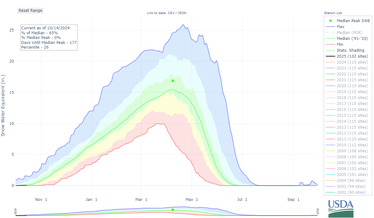
Unfortunately, nearly no measurable precipitation has been recorded in Colorado’s mountains during the first 15 days of October, according to the National Weather Service in Boulder. The last date the state’s mountains received any measurable precipitation (between a trace and 0.5 inches) was Sept. 22 — the first day of fall.
But currently the storm’s track has its eye fixed mostly on the southern mountains, bringing snow from Friday night through Sunday evening.
Recap:
Monday was mostly another warm and dry day in the mountains, with highs in the 50s and 60s from Steamboat to Silverton, with spotty rain showers delivering little precipitation via southwesterly flow to the San Juan Mountains.
Copper Mountain’s high on Monday was 55, according to AccuWeather.com.
Forecast:
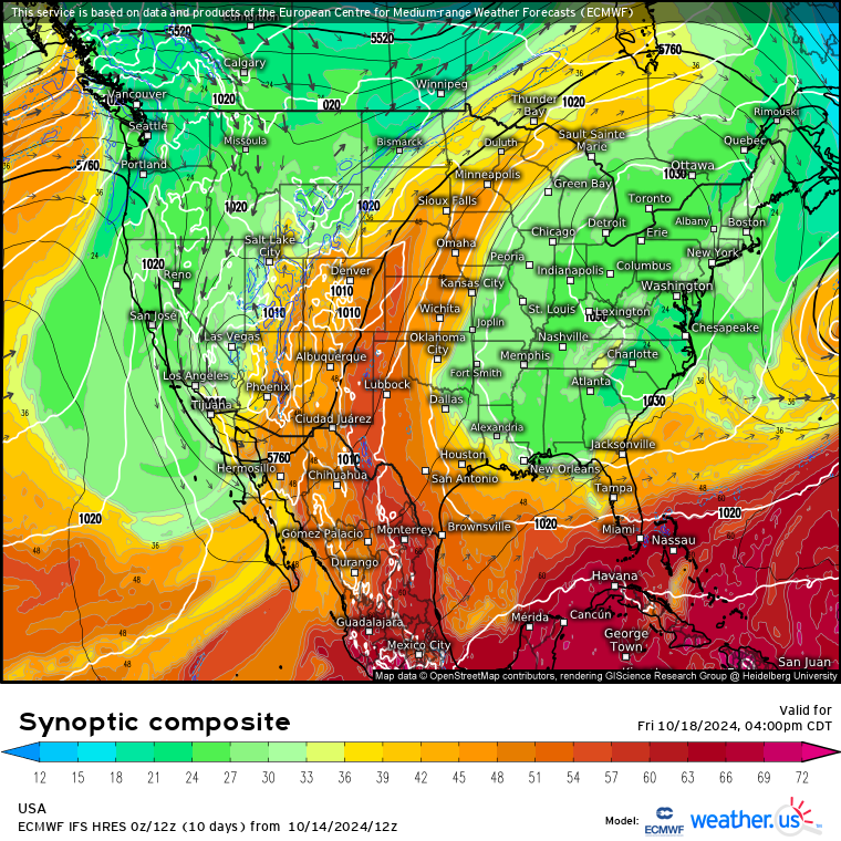
Tuesday and Wednesday will offer mostly calm, dry and sunny weather, but come Thursday, the high pressure dome that has been parked over between the Four Corners and Texas/Oklahoma panhandles will push eastward allowing for a dipping low pressure to work its way into the southwest.
Moisture will funnel in Wednesday ahead of Friday’s main low pressure system, bringing higher chances of rain and mixed rain/snow showers and lower temperatures to Colorado. According to the NWS in Boulder, chances of rain on Wednesday and Wednesday night are 20%, with a 30-40% chance of rain in Silverton.
Thursday’s highs will only reach the upper 40s and lower 50s in the mountain valleys below 9,000 feet, while snow potentially could begin to accumulate on the peaks, especially in the southwestern mountains. The synoptic composite forecast from the European Center for Medium-range Weather Forecasts show a dipping low pressure, cut off from the main jet stream to the north, into the southwest over southern Nevada, which will push moisture up into Colorado Friday.
Temperatures might limit snow accumulations on Friday afternoon at first, but heading into Saturday, temperatures are forecast to become more favorable — the high in Silverton is forecast to be 43 — down to 8,000 feet, allowing for potential heavy snow accumulations above that mark.
The ECMWF IFS high-resolution model has forecasted snow totals between 10-16 inches by Monday sunrise, potentially up to 2 feet, for the San Juan Mountains. Farther north and east, snow totals between 6-12 inches for the central and 2-6 inches for the northern mountains are possible.
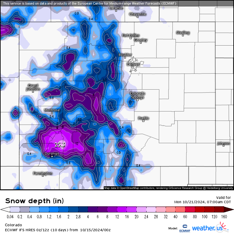
The map above shows total snow depth not total snow fall. However, since there is little to no snow currently on the ground, the forecast map indicates total snow depth from the ground base, with additional higher numbers added onto it over the course of the winter after more snow events.
Snow showers continue into Sunday and Sunday night before the low kicks eastward. Don’t be surprised if Silverton Mountain’s ski patrol takes advantage of the potentially well-filled in snow fields high up on mountain and posts photos of the newly fallen snow.
Long Range:
Monday through Thursday next week brings backs more fall-like weather, with high temperatures returning to the 40s and 50s and more drying.
Editor’s note: Once a few ski areas and resorts open for the season, the Whiteout ski area conditions map will be updated semi-daily with information about conditions, open trails and 24-hour snow totals.
Today’s 24 hour snow totals from Colorado resorts:
Arapahoe Basin – Closed for season
Aspen Highlands – Closed for season
Aspen Mountain – Closed for season
Beaver Creek – Closed for season
Breckenridge – Closed for season
Buttermilk – Closed for season
Cooper – Closed for season
Copper Mountain – Closed for season
Crested Butte – Closed for season
Echo Mountain – Closed for season
Eldora Mountain – Closed for season
Granby Ranch – Closed for season
Hesperus – Closed for season
Howelsen Hill – Closed for season
Kendall Mountain – Closed for season
Keystone – Closed for season
Loveland – Closed for season
Monarch – Closed for season
Powderhorn – Closed for season
Purgatory – Closed for season
Silverton – Closed for season
Snowmass – Closed for season
Steamboat – Closed for season
Sunlight – Closed for season
Telluride – Closed for season
Vail – Closed for season
Winter Park – Closed for season
Wolf Creek – Closed for season