


30″ of snow could fall in Colorado with three winter storms expected
At long last, a shift in the weather pattern should start to bring more consistent snow to Colorado as mid-February starts to hit.
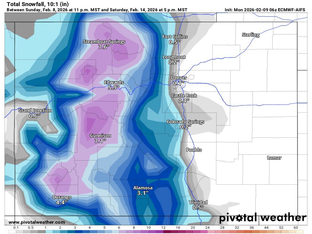
A first wave of snow is expected to start in northern Colorado on February 10, pushing south as it continues into February 14. By the time snow stops falling, decent accumulation should span most mountainous regions of the state. According to Pivotal Weather widespread totals between seven and nine inches can be expected – though that might be a conservative estimate.
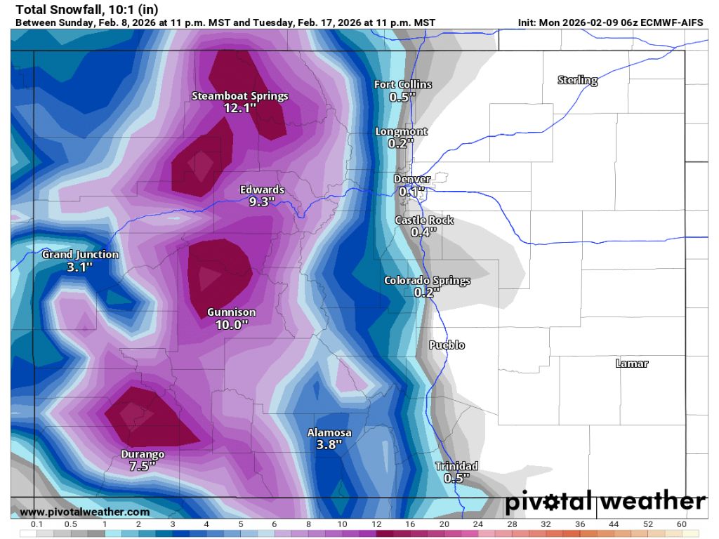
After that first wave of snow, more is expected on February 16, continuing into the following day. This round of snow should drop similar totals in the seven to nine-inch range on many peaks, as well. By this point, peaks in the Aspen area, Steamboat Springs, and those north of Durango should have accumulated around 14 to 16 total inches of snow – again an estimate that may be on the conservative side.
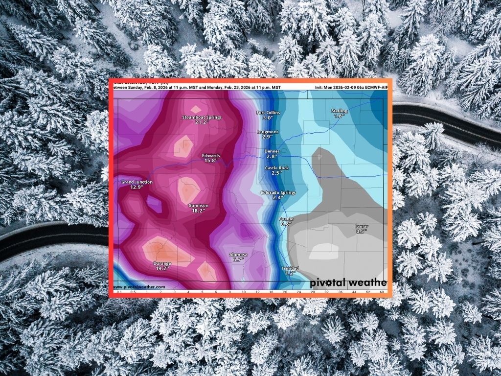
A third round of snow should then start during the early hours of February 19, with on-and-off snow expected through at least February 23. By this point, San Juan peaks north of Durango should have the most accumulation – about 32 inches of snow between the first wave of snow that starts February 10 and then. Meanwhile, the Flat Tops, the Sangre de Cristos, the Elks (near Aspen), and the Park Range (near Steamboat Springs, should all have a two-week accumulation total of about 25 inches or above – and for the third time, this estimate also may be a bit on the conservative side.
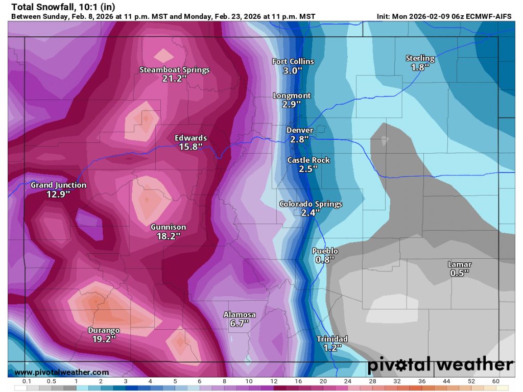
Most Front Range cities should see some snow over this period, though totals should be relatively limited. Along the I-25 corridor, Colorado Springs and cities north of that should get between two and three inches, though more should land in the foothills to the west of these population centers.
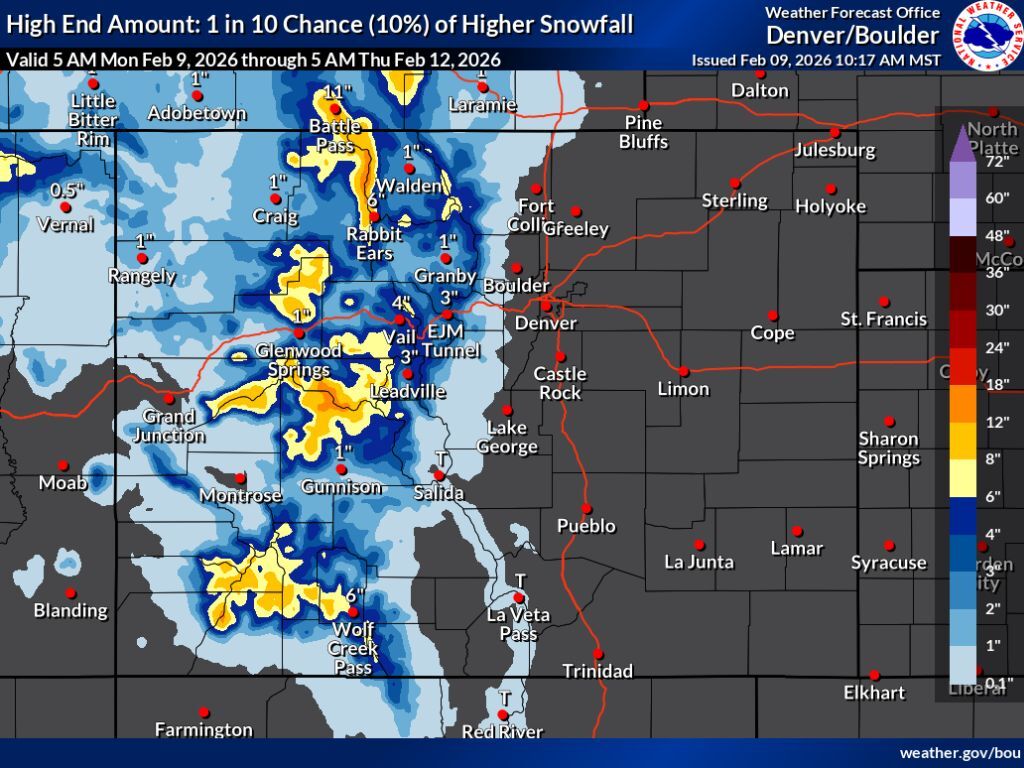
As noted, more snow than the aforementioned estimates could end up falling in some localized areas. According to OpenSnow, Steamboat Resort, Crested Butte, and Silverton should all get about 12 inches of snow or more over the next five days – Steamboat leading the charge at about 15 inches of fresh snow. This OpenSnow prediction is moreso in line with the National Weather Service ‘high-end’ snowfall forecast, which depicts the potential for eight to 12-plus inches on some Colorado peaks through the morning of Thursday, February 12.
As of February 9, Colorado’s statewide snowpack is still far below the norm for the date – 53 percent of what’s typical. Some specific regions are even drier – southwest Colorado, for example, is at about 44 percent of its region norm.
STAY INFORMED: Get free Colorado news with our daily newsletter (Click here)
Get OutThere
Signup today for free and be the first to get notified on new updates.
PREV
PREVIOUS

Longs Peak climbers become incapacitated at 14,000 feet during winter push to summit
A rescue took place on Colorado’s 14,259-foot Longs Peak last Friday, highlighting how winter risks are still present in the state’s backcountry despite the general lack of typical snowpack. According to a press release from Rocky Mountain National Park, two male climbers age 47 and 50 requested assistance after becoming incapacitated while climbing Longs Peak’s […]

23 'red flags' to watch out for when it comes to dating in Colorado
Coloradans are great to date, right? With stereotypes of being adventurous and athletic often holding true, having a Coloradan in your life is sure to be exciting. That said, it’s not all sunshine and roses. Here’s a list of ‘red flags’ when it comes to dating in Colorado: What’s another ‘red flag’ when it comes […]