


“Intense supercells will be possible”: Denver metro and I-25 corridor at risk of big hail
It’s another June day in Colorado and another round of serious hail could hit – and this time, the severe storms could have major impacts for the I-25 corridor, including the Denver metro area.
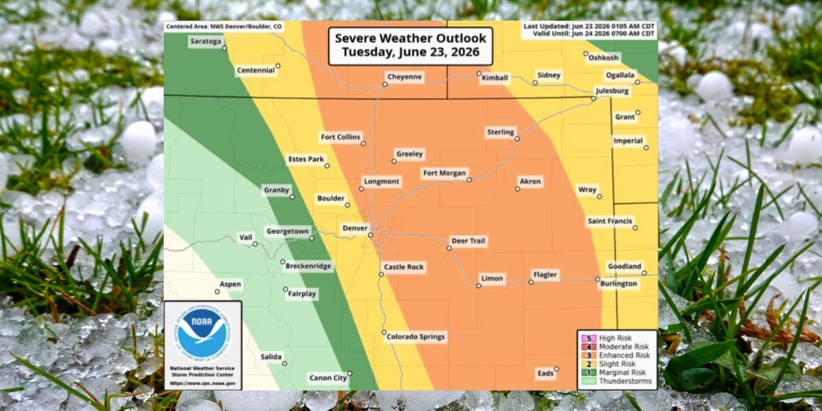
According to the National Weather Service, the timing of possible storms will be 3 p.m. on Tuesday to 1 a.m. on Wednesday, with Tuesday evening bringing particularly high risk.
“A few intense supercells will be possible, capable of producing very large hail exceeding two to three inches in diameter,” reads a warning from the NWS.
The area that could be impacted is very widespread. While many recent storms have put the I-25 corridor at a stage one or two (of five) risk, parts of the I-25 corridor, including Fort Collins and much of the Denver metro area, are at a stage three risk today. As is noted by the National Weather Service, the “threat includes [the] urban corridor.” The Eastern Plains are also expected to get hit hard.
While baseball-size hail is a key threat, tornados will also be possible, as well as damaging winds that could hit about 80 miles per hour.
Be on the lookout for weather alerts on National Weather Service social media channels, as well as the agency’s website.
STAY INFORMED: Get free Colorado news with our daily newsletter (Click here)
Get OutThere
Signup today for free and be the first to get notified on new updates.
PREV
PREVIOUS

Moose attacks hiker with dogs in Pikes Peak region
On Monday evening, Colorado Parks and Wildlife along with Teller County Search and Rescue responded to a moose attack that took place on Lovell Gulch Trail near Woodland Park. The attack occurred at about 6:45 p.m., with the hiker evaluated by a medical team and ultimately released. Following the attack, the hiker’s dogs were briefly […]

Colorado's first arcade bar closes after 15 years – but something big is on the way
After 15 years, Colorado’s first arcade bar has closed its doors – but the spot’s story is far from over. Per a recent announcement, The 1up Arcade Bar located on Blake Street in Denver is now shuttered. That said, the company’s Colfax, Greenwood Village, and Westminster locations are still going strong. That’s not all either […]