


Denver weather: 36-hour winter storm warning in effect for Denver
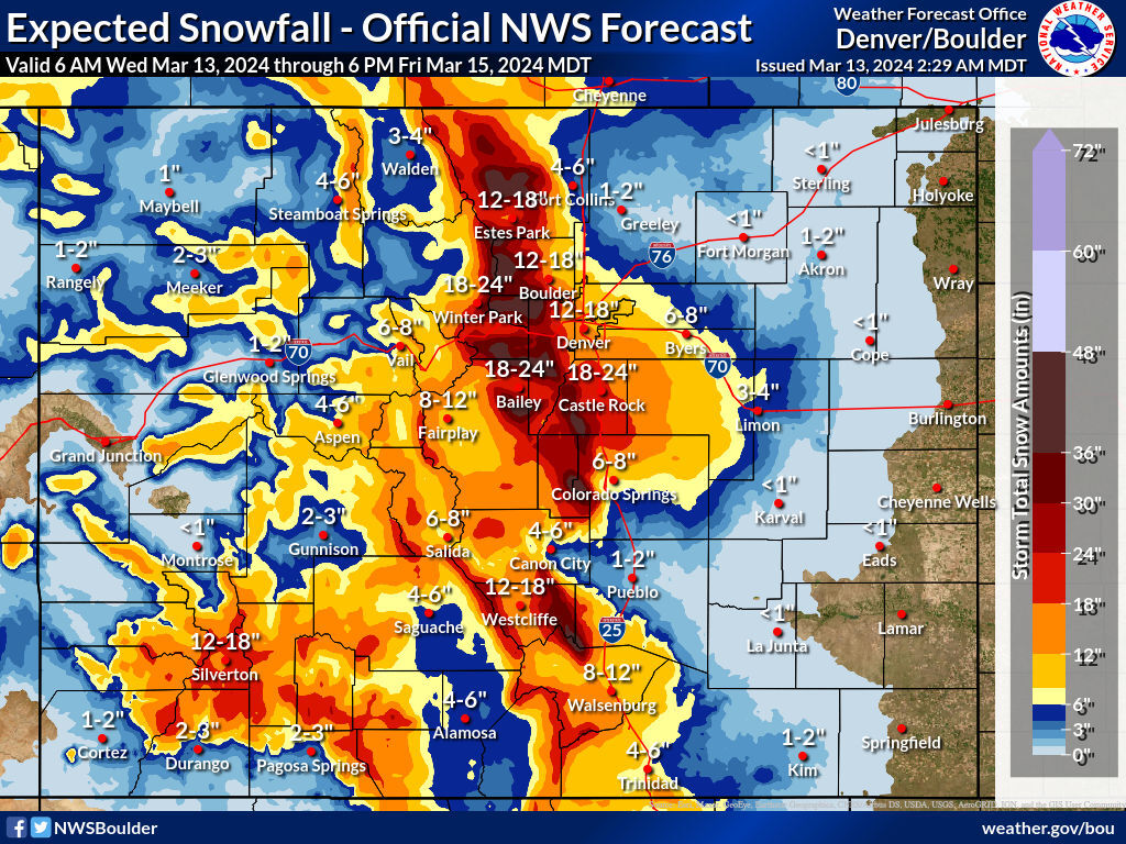
Denver and the metro area are looking at a 36-hour long winter storm warning starting at 9 p.m., Thursday and effective until 6 a.m., Friday, with snow accumulation totals between 8-16 inches with up to 20 inches in localized spots below 6,000 feet.
Denver residents can expect a chance of showers before 4 p.m. Wednesday, then a chance of showers and thunderstorms between 4 and 5 p.m., then showers likely and possibly a thunderstorm after 5 p.m., according to the National Weather Service in Boulder.
The Colorado Department of Transportation is preparing residents and travelers for likely closures of major highways — including Interstate 25 between Castle Rock and Colorado Springs, and Interstate 70 west of Denver, from Golden to the Eisenhower Tunnel — if the snow and winds are as extreme as forecasters predict.
It will be cloudy, with a high near 52 and north northeast winds blowing between 5 to 13 mph, with gusts as high as 21 mph. Chance of precipitation is 60%.
For Wednesday night the forecast has rain before 9 p.m., then rain and snow between 9 and 11 p.m., then snow after 11 p.m. The snow could be heavy at times. Some thunder is also possible. Patchy blowing snow after 4 a.m., with a low around 31. Blustery, with a north wind 14 to 20 mph, with gusts as high as 31 mph. Chance of precipitation is 100%. New snow accumulation of 2 to 4 inches possible.
Grand totals by Friday morning around metro Denver will vary, but 6-20 inches can be expected with lower totals farther east of the city and higher totals west and south of the city.
Here’s the full forecast from the National Weather Service.
Thursday: Snow. The snow could be heavy at times. Patchy blowing snow before 8am, then patchy blowing snow after noon. High near 33. Breezy, with a north wind 15 to 18 mph, with gusts as high as 30 mph. Chance of precipitation is 100%. New snow accumulation of 4 to 8 inches possible.
Friday: A 50% chance of snow, mainly before 7 a.m. Mostly cloudy, with a high near 40. North northeast wind 5 to 9 mph becoming east southeast in the afternoon.
Saturday: Mostly sunny, with a high near 47.
Sunday: Mostly sunny, with a high near 47.

Get OutThere
Signup today for free and be the first to get notified on new updates.
PREV
PREVIOUS
Colorado Springs weather: CDOT warns travelers ahead of expected major winter storm
A major winter storm that could drop up to five feet of snow in some areas of the state is moving in, and the Colorado Department of Transportation is preparing residents and travelers for likely closures of major highways – including Interstate 25 between Castle Rock and Colorado Springs, and I-70 west of Denver, from […]

Nearly 50 inches of snow expected on Colorado 14er in upcoming days
While much of the focus of a big storm that’s setting up to hit Colorado has been on travel impacts – with many heavily-populated parts of the state seeing a potential for 18 or more inches of snow, outdoor recreators should also be aware that Centennial State mountain peaks could also be getting big totals. […]