


Colorado region has 617 percent of typical snowpack for this time of the year
Weeks full of precipitation have helped Colorado’s snowpack stick around this spring, with more snow on the way in upcoming days.
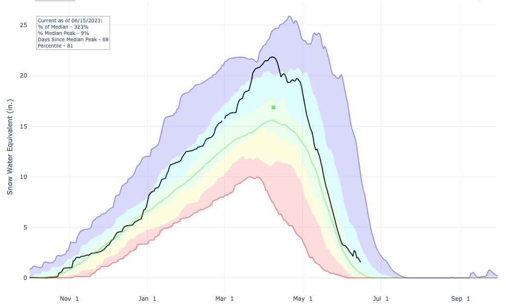
According to the USDA, Colorado’s snowpack is currently at 323 percent of the to-date norm, with an initial steep spring drop-off due to melting slowed by cooler temperatures and more fresh powder. Colorado’s statewide 1.6 inches of snow water equivalent on June 15 is well-above the 0.5 inch norm.
The highest snowpack statewide is found in the Gunnison River Basin, which includes towns of Crested Butte, Gunnison, and Ouray. This is especially shocking, as snowpack in this region during this time of the year is typically non-existent. Meanwhile, the Colorado Headwaters Region, which includes the Central Mountains extending westward along I-70, is at a wild 617 percent of its normal snowpack.
Here’s a breakdown of how snowpack stands in each region compared to the norm for this time of the year:
Arkansas River Basin: 196 percent of median; 0.7 snow water equivalent inches
Colorado Headwaters River Basin: 617 percent of median; 2.5 snow water equivalent inches
Gunnison River Basin: N/A (snowpack is usually at 0 snow water equivalent inches in this region during this time of the year. This year, it’s still at 3.4 inches)
Laramie and North Platte River Basin: 117 percent of median; 2.9 snow water equivalent inches
Upper Rio Grande River Basin: 40 percent of median; 0.1 snow water equivalent inches
San Miguel-Dolores-Animas-San Juan River Basin: 351 percent of median; 0.6 snow water equivalent inches
South Platte River Basin: 276 percent of median; 0.5 snow water equivalent inches
Yampa-White-Little Snake River Basin: 287 percent of median; 5 snow water equivalent inches
With more snow on the way to the state in upcoming days, the snowpack decline is likely to continue at its slow pace in the short-term.
STAY INFORMED: Get free Colorado news with our daily newsletter (Click here)
Get OutThere
Signup today for free and be the first to get notified on new updates.
PREV
PREVIOUS
10 inches of snow could hit Colorado peak, with more moisture on the way
Colorado outdoor recreation enthusiasts – don’t put away those winter layers and traction devices just yet. More snow is on the way. It’s no secret that the last few weeks have been wet ones in Colorado, and it might still be a few more days (or weeks) until that precipitation lets up. With more rain […]

Vail pro-skier nominated for induction into the Warrior Legend Hall of Fame
An honor to individuals who made significant contributions to the 10th Mountain Division