


Major storm could bring up to 36 inches of snow to Colorado this week
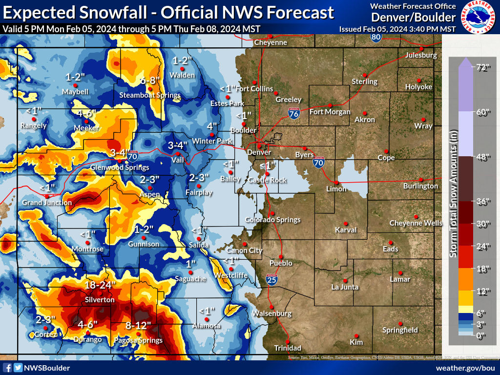
Another round of big snow is set to hit Colorado from Tuesday into Thursday, bringing the possibility of two to three feet of snow to parts of Colorado, according to the National Weather Service.
The heaviest snow is expected in the southwest region, including the San Juans and La Garita Mountains. Deepest totals will be falling above 10,000 feet of elevation, but mountain towns like Pagosa Springs and Silverton could see a foot or more.
Strong winds are also expected to accompany this storm, which will make driving difficult. Gusts of up to 55 miles per hour are possible. This will also likely contribute to major drifting of snow.
Mapping from the National Weather Service shows that up to 36 inches could hit some peaks in the Durango–Silverton–Pagosa Springs area, though snow in the range of 18 to 24 inches could also fall on many of western Colorado’s highest peaks. The Front Range, however, should see very limited snow during this period, with almost no snow expected along the I-25 metro area.
This storm will likely precede another big storm that could hit this weekend.
Big snow from last weekend brought the statewide snowpack up to 91 percent of what’s normal for this time of the year. Some parts of the state got more than 20 inches with at least one notable weather record falling that happened to be set in 1912.
Find the most updated forecast on the National Weather Service website.
Get OutThere
Signup today for free and be the first to get notified on new updates.
PREV
PREVIOUS
Colorado city gets enough snow in 24 hours to break 'monthly' record set in 1912
Wet and heavy snow that fell in the area of Fort Collins between 7 p.m. on Friday and 7 p.m. on Saturday helped to set a pretty remarkable weather record this weekend. For starters, the 1.66 inches of precipitation easily became the wettest single 24-hour February period on record for the area. Even more impressive […]
Murder trial of former Greenwood Village officer starts Tuesday
The trial of a former Greenwood Village Police officer charged with second-degree murder in the November 2021 shooting death of an Aurora teenager begins Tuesday with jury selection today in the 18th Judicial District. Adam Holen, 38, faces a charge of second-degree murder in the death of Peyton Blitstein, 17 on Thanksgiving Eve 2021. Holen […]